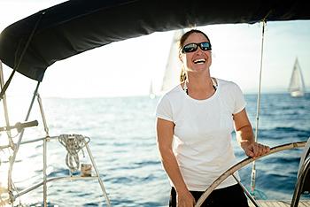
Nowadays there’s much more to your smartphone or tablet for the sailor. It’s now feasible to use mobile technology to help navigate, keep track of tides and currents, and even tie knots. Whether you’re a day cruiser or hard-core racer, there’s an app out there that could help make your sailing life a little bit easier. In this guide, we’ll look at some of the very best apps on the market and help you decide which is the best for you.
Navigation
Wärtsilä iSailor (IOS and Android)
Free (Offers In-app Purchases)

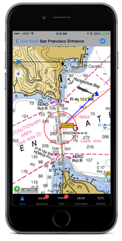
This award-winning navigation app has one of the largest chart databases generated from official vector charts worldwide which are regularly updated for free. The interface offers clear navigation information, electronic charts, and additional content and is recognised worldwide as one of the most reliable and accurate navigation sources. The app utilises either your device’s GPS or an external Bluetooth GPS. The available charts include North America, Latin, and South America, Europe, Africa, Middle East, Far East, Asia, Australia, and New Zealand and are purchased via the iSailor interface. However, the charts do not come cheap with each UK chart area costing £25.99. The extensive list of features includes NMEA heading and Rate-Of-Turn sensors, positioning system based on GPS, NMEA Echo Sounder, NMEA Wind Sensor, tides and currents, charts and routes, sailing guides and regional marinas and much much more. The app is well presented and responsive with excellent waypoint, route and navigation menus.
Navionics (IOS and Android)
Free (offers in-app purchases)
https://www.navionics.com/gbr/apps/navionics-boating
IOS - Navionics - Boating Marine & Lakes
Android - Navionics - Boating HD Marine & Lakes

Voted best on a test by Yachting World, Navionics’ functionality is refined and smooth and is fully customisable. Swapping between normal and sonar views is a one-touch operation and there are various shading options for depth contours. Key navigational features can be enlarged in Easy View enabling them to remain visible even when the chart is zoomed out. Route markers can be created without Navionics+ but you are unable to activate or follow a route. However, permanent features enable you to plan your trip and measure the distance between points, add markers to selected points and check wind forecasts. Navionics+ includes dock-to-dock autorouting which quickly creates detailed routes even through narrow passages and channels based on chart data and navigation aids, advanced route planning with ETA, distance to arrival, heading to WP and fuel consumption. Detailed weather forecasts and weather buoy data and wireless compatible plotter sync are also included within the subscription. The IOS version benefits from a timeline which enables you to look back at your trips in the track Timeline where you can view any photos taken whilst tracking. All in all, Navionics is easy to use and offers the sailor a good all-around package.
INavX (IOS only)
£4.99 (Offers In-app Purchases)
IOS - iNavX: Marine Navigation
The ability to access charts from different providers such as Navionics, CHS, NV Charts and Fugawi, set iNavX apart from other navigation apps on the market. The advanced chart plotter enables the user to plot position in real time using your device’s in-built GPS with easy pan, zoom and rotational charts. Waypoints can be created and routes can be planned accordingly. The track log allows the user to record the actual route and can be integrated with an external GPS, AIS receivers and transponders. The app can also act as a repeater for marine software such as MacENC and supports NMEA data over TCP/IP using wifi. GRIB weather forecasts, tides and currents, an anchor alarm and AIS alarm are also included within the toolkit. The app allows the sailor to switch between platforms without losing stored waypoints, tracks and routes whilst NV raster charts are high resolutions even when fully zoomed in. Named waypoints are displayed and the entire waypoint layer can be switched off if needed. Tidal information can be added with the additional purchase of the AyeTide app. The app is intuitive and comprehensive and is perfect for waypoint management for racing.
Weather
MetOffice (IOS and Android)
Free (Offers In-app Purchases)
IOS - Met Office Weather Forecast
Android - Met Office Weather Forecast
Website - https://www.metoffice.gov.uk/

As well as publishing its shipping forecasts, inshore waters forecasts and gale warnings on their website, the Met Office have also produced an app. Real-time UK National Severe Weather Warnings with the interactive warnings map including saved locations is displayed. Warnings follow the same pattern as those broadcast by the coastguard. Also included are surface pressure charts, wind direction, base and gust strength. An interactive UK wind map is also of use to the sailor as are the weather alerts.
Windy (IOS AND Android)
Free
Website - https://www.windy.com/

Windy is an intuitive and accurate weather forecast app which provides an up-to-date weather forecast. The app allows the user to zoom out to see global weather patterns or to zoom into a local area within a clear and concise interface. The data is based upon ECMWE, GFS, NEMS, NAM, and other forecast models and is one of the most accurate weather apps on the market. The app is fully customisable and displays observed wind and temperature, forecasted weather and even nearby webcams. The data can be displayed in metric, imperial or custom units such as mph, m/s, etc. Detailed forecasts for any location can be displayed and include temperature, wind chill, wind speed, pressure, humidity, rain, and snow accumulation. A range of 28 weather layers can be applied which include weather, wind, temperature, clouds (low, medium and high), visibility, pressure, and even ozone layer.
Predict Wind (IOS and Android)
Free (plus in-app purchases)
IOS - PredictWind Offshore Weather
Android - PredictWind Offshore Weather

This free app allows the sailor to download multiple GRIB files for both coastal and offshore passage. Although expensive, depending on the level of access required (from £9 to £399 per annum), the app offers high levels of detail and one of the highest resolutions and most accurate forecasts available online. The Predict Wind server calculates the weather routing and departure planning with the highest resolution forecast data into a small file size making it ideal for transmission over low bandwidth. The interface is intuitive and easy to use with a resolution of 1km at its best.
Yachting Weather (IOS and Android)
Free

A simple user-friendly app which uses GFS data from weather365.com, giving a three-hourly forecast. The forecasts are based on your current GEO location or any other sea area worldwide determined by GPS. The three-day forecasts (two days on IOS) come in six-hour intervals and are available worldwide. A high resolution, comparable to approximately 12X12 sea miles is advantageous to the sailor allowing changing winds, gusts or rough sea within a short distance to be forecast. Forecast data includes storm risk, wind speed, wind direction, gusts, wave heights and direction, air pressure, temperature, and humidity.
AIS (Automatic Identification System)
Marine Traffic (IOS and Android)
£4.99 for IOS and £3.99 for Android
IOS - MarineTraffic - Ship Tracking
Android - MarineTraffic Ship Positions

Although not intended to replace a boat’s AIS, this app is a handy reference guide which displays near real-time positions of ships and yachts worldwide. Vessels can be viewed on a live map and identified with augmented reality (in-app purchase necessary). Port arrivals and departures for over 4,000 ports and marinas can be viewed as well as current conditions in ports and ETAs for boats and ships. Vessels around you can be identified at a glance by simply pointing your device’s camera to the horizon. The database contains over 2.5 million photos of ships, harbours, and lighthouses and you can upload photos to MarineTraffic directly from your device. Great fun for non-sailing guests.
Other
Ayetides (IOS only)
£7.99

Ayetides simply displays tides and/or currents for over 12,500 locations worldwide without needing a network connection. Viewed either in tabular form or as an interactive graph, the app shows you the tide’s value at any point during the day. Stations can be found on a map or by your current location and are regularly updated. AyeTides XL has been designed for iPad use.
Sail Racer (IOS and Android)
Free plus an annual subscription
Website - http://sailracer.net/

Sail Racer is an additional tool to use alongside standard yacht equipment to help make tactical decisions faster. The app monitors your position to optimise your start and maneuvers based on current, wind, lay-lines and polar data. The app features a visual starting box on the map with moving Time-To-Burn line/area for optimal start timing, easy switching between compass and map and automatic mark coordinates leaving skippers free to concentrate on maximising performance and tactics. Wind gust and lull effects are visualised in a shift bar on top of the compass rose and on the map whilst boat efficiency is calculated according to polar data.
Anchor Watch (IOS and Android)
£0.99

Anchor Watch utilises the GPS on your smartphone or tablet to constantly monitor your boat’s position within set limits. If you drift out of the predefined area the program will immediately alert you via sounds, vibration alerts, popups, email, SMS or even a phone call. The drift radius can be set from 15ft to 75m by the touch of a finger or by manual entry. The settings panel is fully customisable to allow for different alarm types. In-app purchases include advanced nautical maps which can be downloaded and used offline.
Animated Knots by Grog (IOS and Android)
£4.99 for IOS and £4.69 for Android
Android - Animated Knots by Grog

Tying the correct knot in every scenario inspires sailing confidence and can prove vital to safety. Animated Knots by Grog was named best knot-tying app by Outside magazine and is a simple to follow comprehensive tool for any sailor. Step-by-step or frame-by-frame animation illustrates the knots tying themselves. Detailed descriptions of each knots advantages and disadvantages, uses and other information is displayed by tapping the info button. The vast knot database is fully searchable and includes all commonly used knots such as the ubiquitous Bowline and Cleat Hitch to the more exotic sounding Zeppelin Bend. It even includes necktie knots such as the Half Windsor for those nights at the Captain’s table.
Imray Marine Rules and Signals (IOS)
£5.99
IOS - Imray - Marine Rules and Signals

For the occasional sailor, it’s far too easy to forget the basic knowledge and rules of the sea. Leading chart and marine book publishers, Imray have produced this handy reference guide which contains all the rules and signals at sea that you’ll ever need. Illustrated with diagrams and short concise text, a guide is an indispensable tool for any sailor. The app includes steering and sailing rules, day and night time marking of boats, actual sound signals including distress signals and full Colregs text. It also covers buoys and their lights, flags, racing flags, semaphore flags and, radio calls. The content can be scrolled or viewed individually or in sequence. Charts and images can be zoomed and panned. The data is based on the International Regulations for Preventing Collisions at Sea and includes current amendments.